Andrew H. asks:
Good morning Joel,
I have several new lakes I want to try fishing but the kicker is there’s no lake map. My question is how do you approach a new lake that has no lake map?
Thanks, Andrew
This is a great question, and something I'm faced with anytime I fish something off the beaten path. Over the years, I've found a few ways of getting at that problem, though it does involve some digital reconnaissance as well as some on-lake interpretation.
From a digital perspective, here are just some of the resources I utilize:

MN DNR Recreation Compass - useful resource for just looking around and understanding how/where to navigate to
MN Landview - online GIS platform to compare multiple natural resources layers, aerial photos, etc.
MN Lakefinder - even when there's not a lake depth map, the other tabs, like "water quality" databases can provide very useful information. For example, on this lake, though there's no depth map, I know that max depth is sampled at 13 feet, making me comfortable that it can withstand winterkills and maintain a fish population. Not to mention, I know it's likely a shallow depression with little in the way of offshore structure:
After sleuthing what database information I can, I next look to aerial photos, primarily with Google Earth. Comparing historically different dates of photography is ultra helpful, especially in larger water bodies with no map that also contain offshore structure. This is especially useful in remote areas like the Boundary Waters Canoe Area. Compare these two dates of photos, with the second showing you just how shallow and boggy a portion of this lake really is. Only look at one date, and you'd be misled:


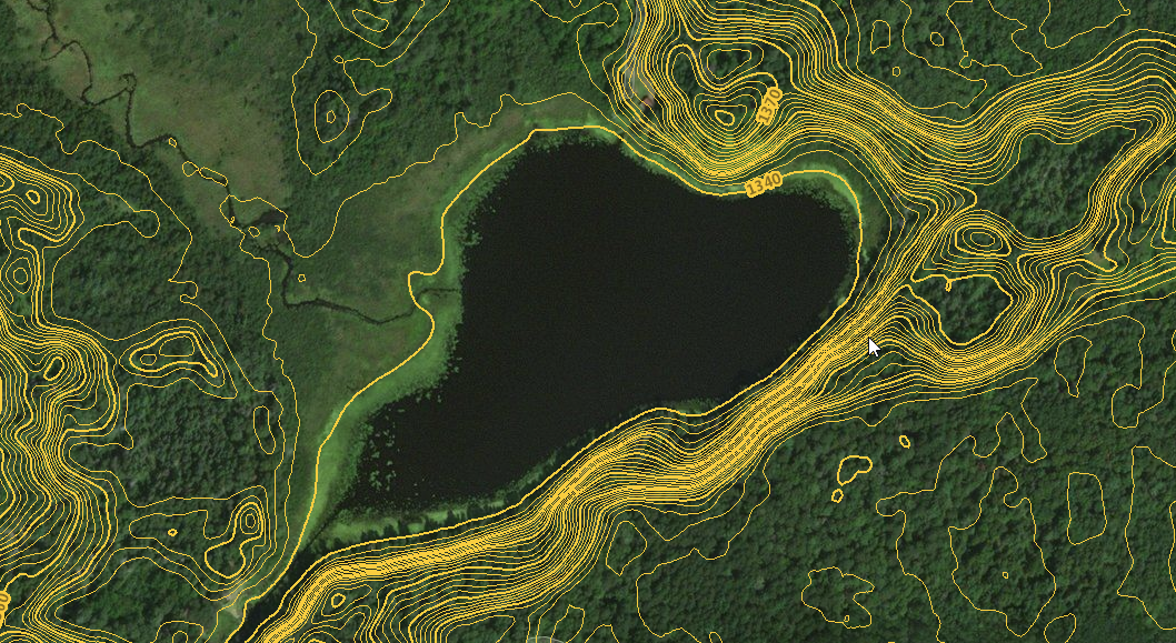
From here, I turn to elevation information from the shoreline. Often, shoreline features are great indicators of what's going on beneath the water surface as well. For this resource in MN, I utilize LiDAR elevation information, which may or may not be available where you fish:
MN TOPO - LiDAR Elevation Website - For example, on the below lake, you've got a pretty good idea of where the steepest breaks will be based just on shoreline elevation.
On The Water - From here, you need to use your electronics, plenty of holes, and a good amount of determination to mentally map the lake bottom. Always in the back of your brain be conceptualizing how a lake bottom looks like while you push on. Let your focus first guide understanding of the structure, or lack thereof, and what it's doing to fish you mark. People rush to the fishing part too quickly without fully understanding what's going on below. A bit of time working on the front end, usually translates to better catching on the backside.
Fishing these bodies of water constitutes some of the best fishing, and most fun I have annually. Of course we strike out constantly, but finding a gem of your own makes it worthwhile.